


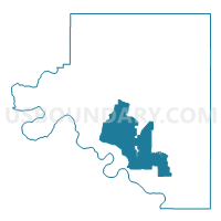
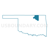
Voting District 306, Osage County, Oklahoma
About
Outline

Summary
| Unique Area Identifier | 654896 |
| Name | Voting District 306 |
| County | Osage County |
| State | Oklahoma |
| Area (square miles) | 198.10 |
| Land Area (square miles) | 194.85 |
| Water Area (square miles) | 3.25 |
| % of Land Area | 98.36 |
| % of Water Area | 1.64 |
| Latitude of the Internal Point | 36.44582460 |
| Longtitude of the Internal Point | -96.43727230 |
Maps

Graphs
Select a template below for downloading or customizing gragh for Voting District 306, Osage County, Oklahoma


Neighbors
Neighoring Voting District (by Name) Neighboring Voting District on the Map
- Voting District 107, Osage County, OK
- Voting District 111, Osage County, OK
- Voting District 112, Osage County, OK
- Voting District 203, Osage County, OK
- Voting District 204, Osage County, OK
- Voting District 301, Osage County, OK
- Voting District 304, Osage County, OK
- Voting District 305, Osage County, OK
- Voting District 307, Osage County, OK
Top 10 Neighboring County Subdivision (by Population) Neighboring County Subdivision on the Map
- Southeast Osage CCD, Osage County, OK (24,485)
- Pawhuska CCD, Osage County, OK (7,532)
- Hominy CCD, Osage County, OK (5,983)
- Barnsdall CCD, Osage County, OK (3,226)
- Fairfax CCD, Osage County, OK (2,106)
Top 10 Neighboring Place (by Population) Neighboring Place on the Map
Top 10 Neighboring Unified School District (by Population) Neighboring Unified School District on the Map
- Cleveland Public Schools, OK (9,233)
- Pawhuska Public Schools, OK (5,022)
- Hominy Public Schools, OK (4,550)
- Prue Public Schools, OK (2,697)
- Woodland Public Schools, OK (2,682)
- Wynona Public Schools, OK (786)
Top 10 Neighboring State Legislative District Lower Chamber (by Population) Neighboring State Legislative District Lower Chamber on the Map
Top 10 Neighboring State Legislative District Upper Chamber (by Population) Neighboring State Legislative District Upper Chamber on the Map
Top 10 Neighboring 111th Congressional District (by Population) Neighboring 111th Congressional District on the Map
Top 10 Neighboring Census Tract (by Population) Neighboring Census Tract on the Map
- Census Tract 9400.01, Osage County, OK (5,983)
- Census Tract 9400.02, Osage County, OK (5,029)
- Census Tract 9400.03, Osage County, OK (4,820)
- Census Tract 9400.07, Osage County, OK (4,674)
- Census Tract 9400.08, Osage County, OK (3,226)
- Census Tract 9400.09, Osage County, OK (3,216)
Top 10 Neighboring 5-Digit ZIP Code Tabulation Area (by Population) Neighboring 5-Digit ZIP Code Tabulation Area on the Map
- 74070, OK (13,928)
- 74056, OK (5,720)
- 74035, OK (4,565)
- 74637, OK (1,899)
- 74650, OK (693)
- 74084, OK (628)
- 74060, OK (586)